Street Smart Planning
Street Smart Planning
How searching for delicious cocktails led to a revelation on street design

One Thursday night, a friend and I made our way through Lower Nob Hill to check out Bottle Club Pub, the latest in a series of new bars I had set out to explore. It had been a while since I’d gone out in the neighborhood and as we were making our way downhill, I started wondering why it had been so long. Lower Nob Hill is filled with a bunch of great restaurants and bars, and it’s close enough to home to be easily accessible. But as we made our way, my friend commented that something about the neighborhood felt off, and I couldn’t help but feel the same way. Unlike other neighborhoods I venture out to, there was just something uncanny about Lower Nob Hill. And what annoyed me was that I couldn’t put my finger on what it was.
Lower Nob Hill is in fact, a beautiful neighborhood. Walking down Jones and passing Sutter, we ambled by ornate buildings along beautiful tree-lined sidewalks. What was off about that? My first thought was maybe it was the hill, since it’s an extremely steep neighborhood. But San Francisco’s hills have never bothered me, and I didn’t see why it would be the case here. Could it be perhaps that, knowing I’m close to the notoriously seedy Tenderloin neighborhood, I’m already on edge? Considering the fact that the Tenderloin is one of my premier destinations for excellent food and drinks, it seemed pretty unlikely.
As we were about to cross the street, we were met with a rush of traffic. Surrounded by cars and in the middle of empty sidewalks, the problem finally dawned on me. The reason the neighborhood feels so uncomfortable is because it’s a completely hostile place to be a pedestrian. With small sidewalks and cars going faster than you would expect in the middle of downtown, the space feels like it’s designed more for drivers in mind.
And as it turns out, data confirms how unsafe the neighborhood is for pedestrians. Several studies have found that downtown neighborhoods like Lower Nob Hill, the Tenderloin, SoMa, and the Financial District are more likely to see pedestrian accidents. Vision Zero SF, created by the city with the goal of reducing traffic deaths to zero, has mapped out the most dangerous streets in San Francisco, most of which are concentrated downtown.

Why are so many accidents concentrated here versus other neighborhoods? A major reason is the fact that these neighborhoods are San Francisco’s densest, so it’s much more likely for a vehicle to hit a pedestrian considering the amount of foot traffic. However, when it comes to which intersections have the most injuries per crossing, these neighborhoods barely register. Intersections in outer neighborhoods like Corona Heights, Candlestick Point, and Diamond Heights, are much riskier for pedestrians.
But downtown still isn’t great for pedestrians considering the number of accidents, and improving safety should be a priority. How can we reduce pedestrian injuries? Well, the number one factor in traffic injuries is driver speed. And the design of downtown streets has two major flaws that make speeding much more likely.
One is the fact that there are many one-way streets going through the neighborhood. One-way streets facilitate traffic flow since they eliminate tough left turns, reducing congestion. But the effect of this is cars moving much faster, meaning a higher likelihood of pedestrian injury. Is this worth letting traffic move more quickly? From my own experience riding Ubers downtown, traffic actually doesn’t always move faster. I’ve been stuck in gridlock countless times, even with all the one-way streets. One civil engineer is even questioning the congestion benefits of one-way streets, specifically when it comes to shorter trips.
Another reason is the fact that the streets themselves are so wide. Wide streets encourage speeding and increase the risk of pedestrian injuries. From my experience as a driver, being on a wide street surrounded by traffic on both sides gives me the impression of being on a freeway. Compare that to driving on a narrow street, which feels much more claustrophobic. I tend to naturally slow down because of more limited visibility and feeling pressed in by pedestrians and businesses on both sides of my vehicle. Combining one-way streets with width, there is less of a need to moderate speed since drivers don’t need to worry about oncoming traffic.
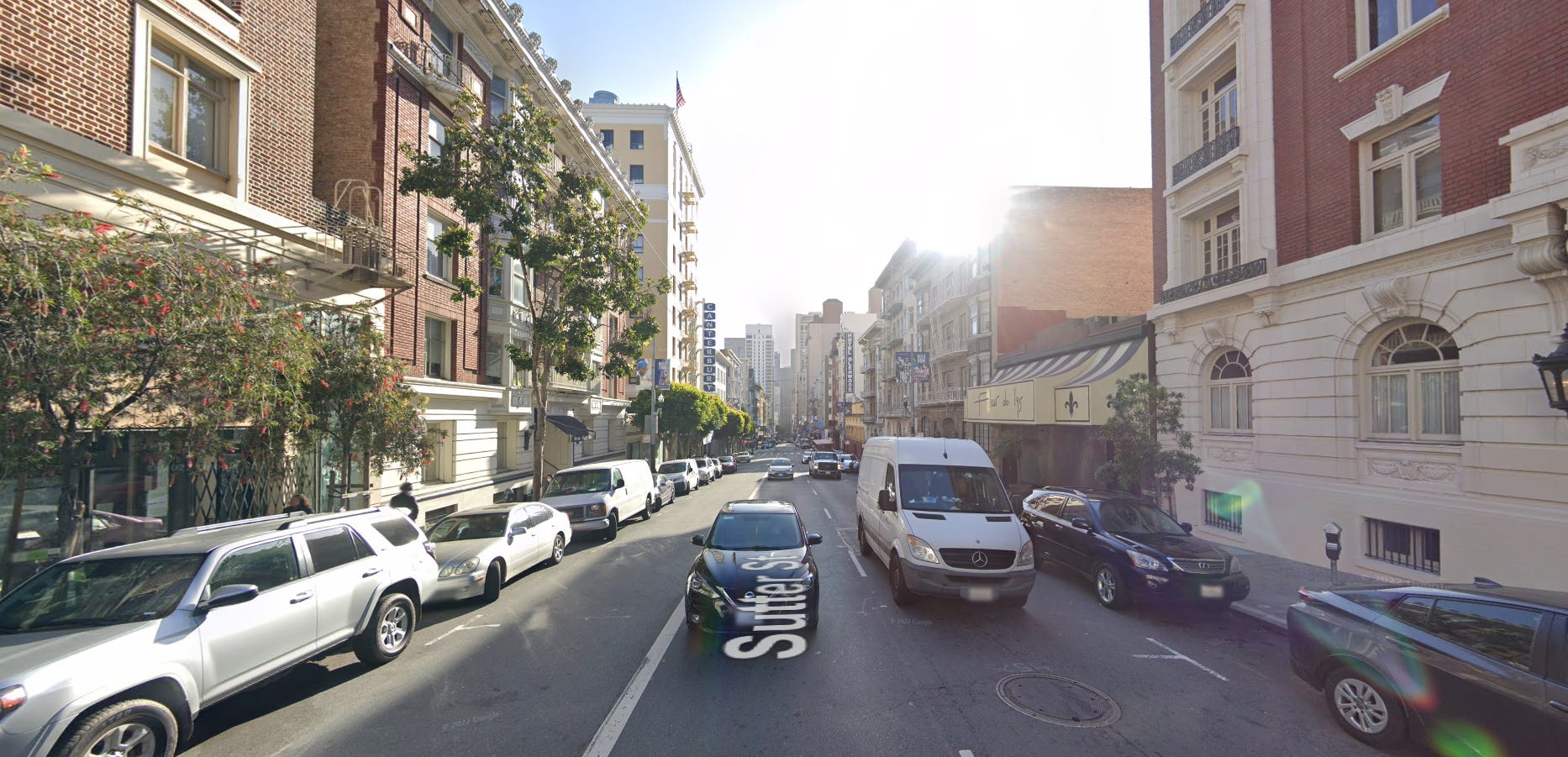
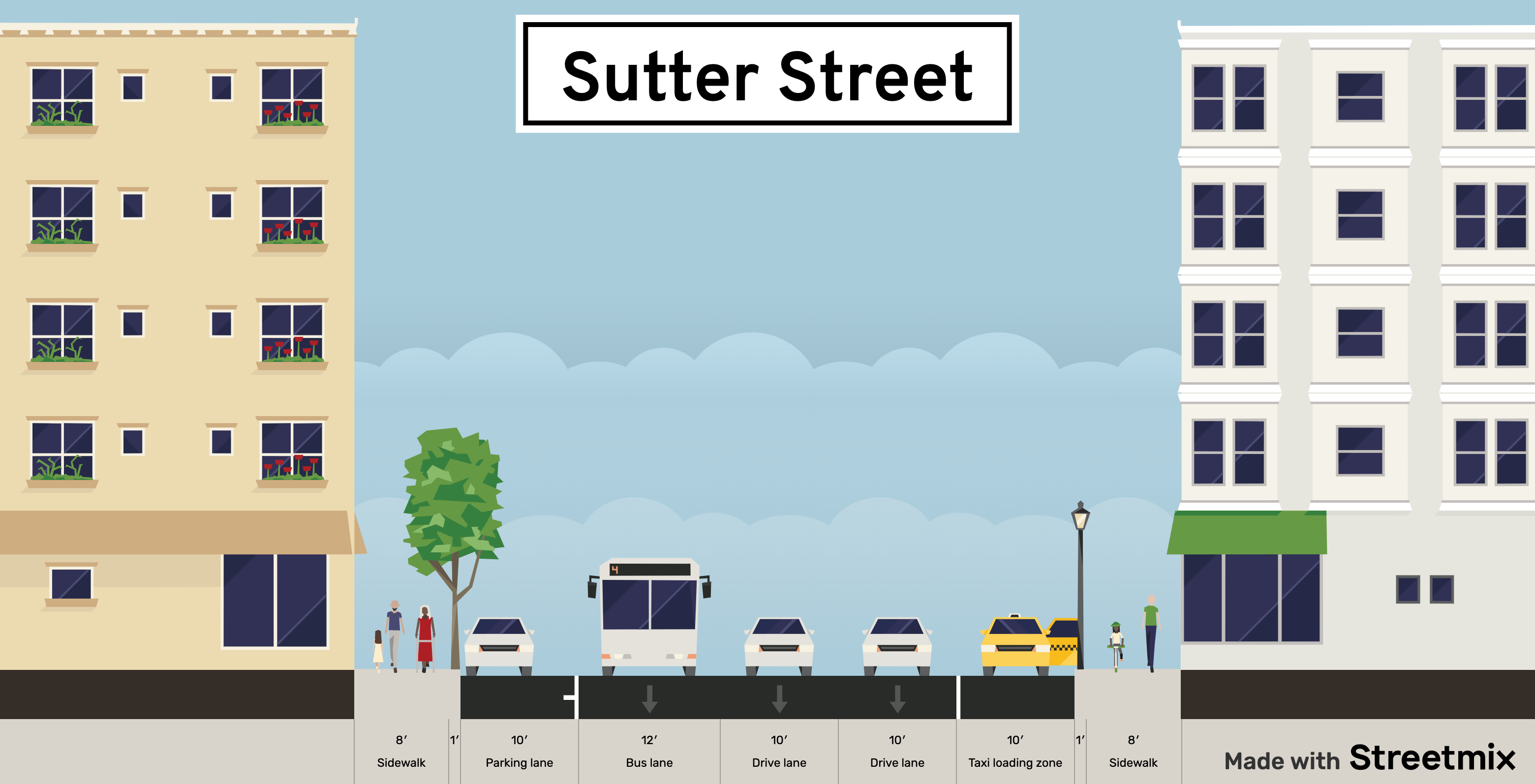
Sutter Street in Lower Nob Hill is a wide one-way street and is definitely not a place I feel very comfortable walking around in. Sutter Street at Jones is a 5-lane street, with 1 bus-only lane, 2 driving lanes, and 2 parking/drop-off lanes bordered by sidewalks. It’s estimated to move 38,000 people per hour. Standing on a corner really gives the impression of being next to a freeway with the number of cars blazing by. Sitting in the restaurant parklet at Matador on Sutter, I’ve felt the air from passing cars whoosh by, leading to an uneasy dining experience imagining myself splattered like the bowl of refried beans I’m eating.
So what would a safer Sutter Street look like? Unfortunately, it’s not like we can push the buildings closer together to narrow the street and offer a cozier experience for pedestrians and moderate vehicle speed. But there are other changes that can be made to create a safer setting for people on foot.
One option would be converting the street back into a two-way street to naturally slow down vehicle traffic. These streets weren’t always one-way streets, with most of them being converted in the late 1940s. Living in Nob Hill, the two-way streets north of California Street really do seem to regulate traffic, as I rarely see cars speeding by like they do in Lower Nob Hill.

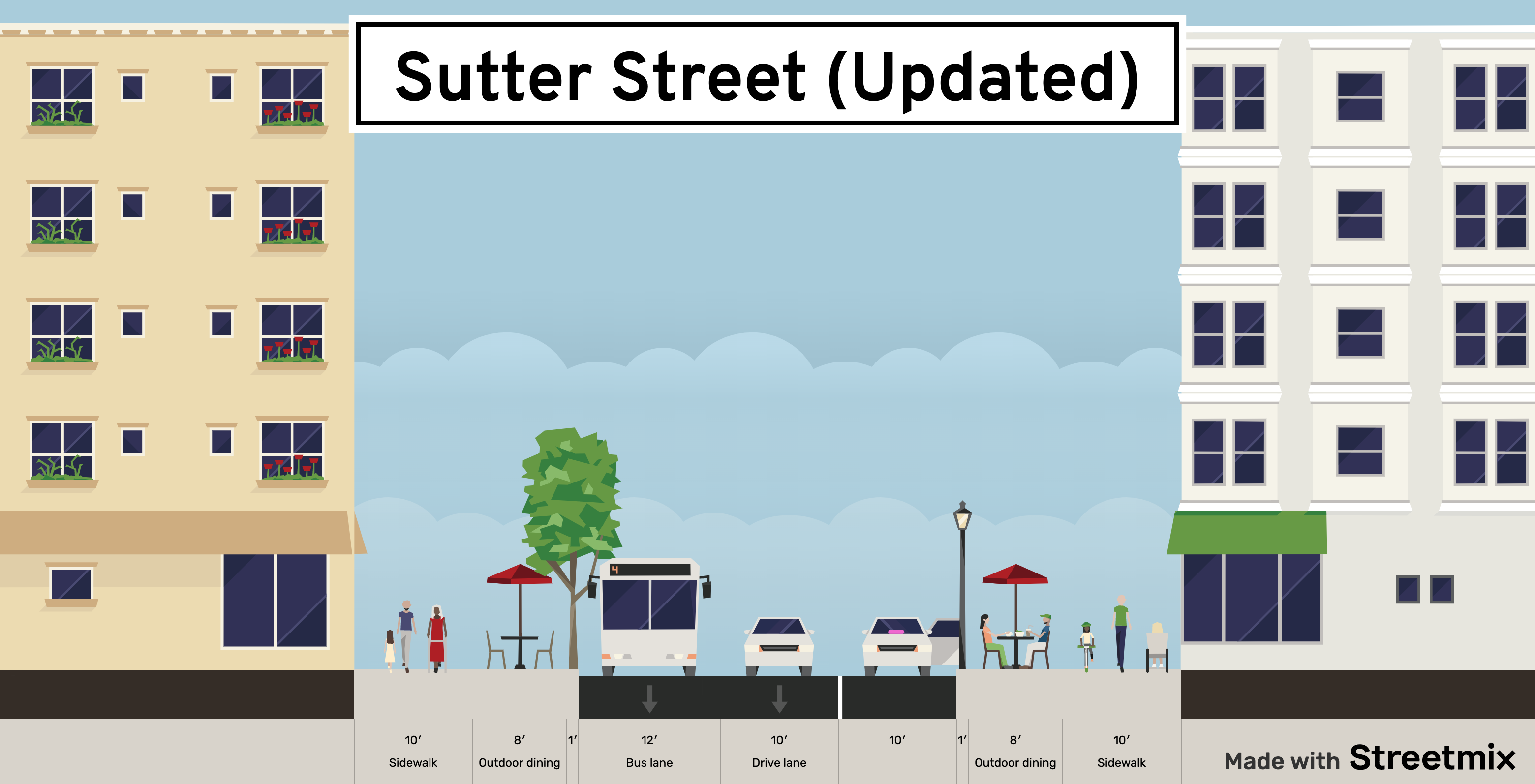
But my personal preference for modifying the street would be a little more involved. Expanding the sidewalk and removing a lane of traffic would help pedestrians feel safer while at the same time nudging cars to drive more slowly. Removing a lane of traffic might feel like a big deal, but it only reduces the number of people per hour moved to 36,500 (a 4% decrease). While we’re at it, let’s remove a parking lane to expand the sidewalk and have more space for outdoor dining and seating. Instead of feeling like a freeway, Sutter Street could be changed to be a place pedestrians feel much more comfortable eating, shopping, and hanging out.
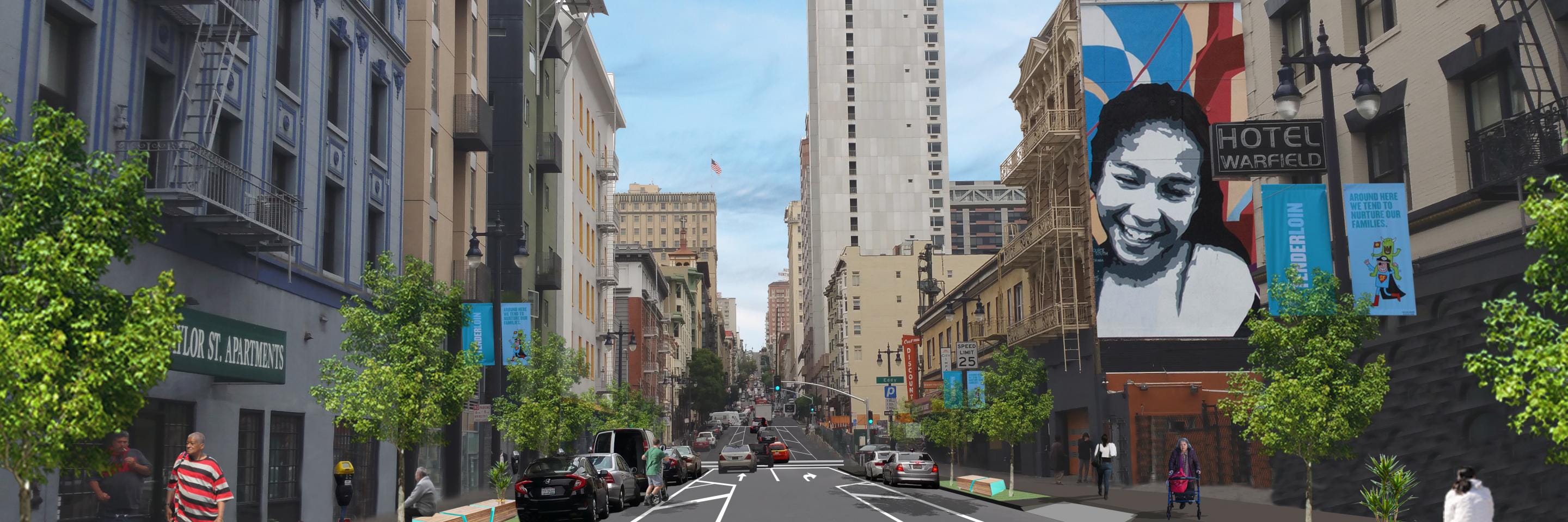
This might seem like a totally outlandish idea, but the city actually began work on a similar project this year. The Safer Taylor Street project is reducing the number of traffic lanes as well as widening sidewalks and enhancing the streetscape, all with the goal of reducing driver speed and improving pedestrian safety. I would love to see other projects like this initiated across downtown for a more vibrant and pedestrian-friendly experience.
Unfortunately, these changes aren’t happening fast enough. Vision Zero’s goal is zero pedestrian deaths, but we’re already at 15 this year as of writing. With an incredibly bureaucratic process and an easy way for anyone to delay a project, Vision Zero isn’t aggressive enough for the change that needs to happen. And sadly, San Francisco voters rejected Proposition A, which would have allotted $400 million for transit improvements and street safety.
Fortunately, organizations like WalkSF and the San Francisco Bicycle Coalition are putting pressure on the city to improve pedestrian and biker safety. Many of us in SF YIMBY are passionate about building better and safer experiences for pedestrians. But it will take more people paying attention and noticing the uncanny experiences they have walking around car-centric neighborhoods.
So next time you’re taking a stroll in Lower Nob Hill (or wherever you are), pay attention to that experience and compare it to the streets you consider comfortable and pleasant. You might be surprised to realize that the gap between your ideal street and the one you’re on isn’t as big as you think.